JAPAN EARTHQUAKE AND TSUNAMI RELIEF
100% of all contributions received have been used exclusively to help people in Japan, supporting local Japanese organizations caring for the most vulnerable people affected by the earthquake and tsunami, with special focus on people with disabilities and the elderly.- $6 million from thousands of generous donors worldwide
- $3.98 million in grants (66% of total funds raised) to 9 Japanese relief and recovery groups
- 4% of total funds raised spent on program management and oversight
- $1.8 million (30% of total funds raised) earmarked to support the long-term needs of the most vulnerable people
THE EVENT
On March 11, 2011, a magnitude-9.0 earthquake and subsequent tsunami and nuclear disaster struck northern Japan, killing over 16,000 people and leaving at least 3,000 missing. More than 5,400 people were injured and over 34,000 people were evacuated. The earthquake and tsunami damaged or destroyed more than 900,000 buildings.
THE PARTNERSHIP
Immediately following the disaster, Direct Relief and the Japanese American Citizen’s League (JACL) established the Japan Relief and Recovery Fund, committing 100% of all contributions to be used exclusively to help people in Japan in the most productive, efficient manner possible.

Read more >>
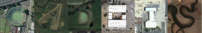
Here's where the aid went. (Interactive map)
日本地震和海嘯賑災
100% 收到的所有捐款已專款專用於幫助日本民眾,日本當地組織以關心受到地震和海嘯影響最脆弱者,尤其是殘疾和老人。
- 世界各地 數以千計的慷慨捐助者600萬美元
- 398萬美元的贈款(募集資金總額的66%)至9個救災和復災團體
- 提高資金總額的4%於計畫管理和監督
- 180萬美元(募集資金總額的30%),專門用於支持最脆弱人群的長期需求