Dynamic View:

12/27/2011

菲律賓瓦西颱風災害地圖 / Google Crisis Map - Typhoon Washi (Sendong)


瓦西(Washi)颱風在當地時間16號星期五深夜,夾帶著強風豪雨,引發大量洪水和土石流,沖進菲律賓南部民答那峨島的河濱與沿岸村莊,重創該島「卡加揚德奧羅」(Cagayan de Oro)和「伊里甘」(Iligan)等地,造成嚴重傷亡,摧毀1萬多間房屋並造成30多萬人流離失所,這些民眾如今大多待在緊急避難所。
菲律賓國家減災風險管理委員會(National Disaster Risk Reduction and Management Council)負責人拉莫斯(Benito Ramos)說,遠至菲律賓中部莫好島(Bohol)的漁民,都在幫忙打撈被沖到好幾百英里外的遺體。
拉莫斯接受廣播電台訪問時說:「只要海中有遺體,搜尋與打撈作業就會持續進行,甚至新年以後也是如此。」當局已經把搜索區域擴大到半徑300公里範圍。


Washi, known locally in the Philippines as Sendong, began as a tropical depression on December 13, 2011 in the West Pacific Ocean about 2150 km (~1333 miles) due east of the southern Philippines. Washi only intensified slightly and never exceeded tropical storm intensity as it tracked due west towards the southern Philippines’ island of Mindanao.

Washi made landfall on the east coast of Mindanao on the afternoon of Dec. 16 as a moderate tropical storm with sustained winds reported at 55 knots (~63 mph). Despite its modest intensity, Washi had a huge impact on the island. As Washi made its way across Mindanao, it dumped heavy rains over parts of the island, which in turn triggered flash floods and mudslides.

Rainfall estimates from the TRMM data are shown here for the period Dec. 13 to 20, 2011 for the southern Philippines. Storm symbols mark Washi's track. Rainfall totals are on the order of 200 to over 250 mm (~8 to 10 inches, shown in green and yellow) along Mindanao's east coast where Washi made landfall, but the highest amounts are along the northwest coast, where totals are on the order of 300 to over 400 mm (~12 to over 16 inches, shown in orange and red). Credit:  SSAI/NASA, Hal Pierce

Image Credit: NASA/SSAI, Hal Pierce
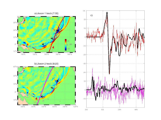
NASA’s Tropical Rainfall Measuring Mission (TRMM) satellite produced the image above late on December 15, 2011. In this image, it shows the tallest thunderstorms in the storm that reached around 15 kilometers or approximately 9.3 miles. The TRMM estimated only heavy rainfall located in the southwest quadrant of the storm early on December 15. By that evening, the storm had intensified and was showing rainfall estimates of at least two inches (50 mm) per hour in the east, north, and western quadrants. Some areas across the region, including Mindanao, saw rainfall totals you would typically see in a month in just one day. Everyone pays attention to the winds of a tropical system, but the biggest threat from any tropical cyclone is heavy rain, flooding, and storm surge.

Google's Person Finder

Tagahanap ng Tao: Bagyong Sendong

Person Finder: Typhoon Sendong


Google Crisis Map - Typhoon Washi (Sendong)

NASA’s Earth Observing-1 (EO-1) satellite image : view & download

More NASA’s EO-1 satellite images

DISASTER BROUGHT BY TYPHOON WASHI (LOCALLY CALLED TYPHOON SENDONG)
Philippine flood devastation, BBC News, More Pictures ....
Typhoon Washi slams Philippines, REUTERS, More pictures .....


via: Google Crisis ResponseNASA’s Earth ObservatoryEarthSky.orgBBC NewsREUTERS, The Watchers中央廣播電臺

12/23/2011

噪音污染地圖 / Sound Pollution on Google Maps

AirCasting 用於測量室外噪音,是一個用您的智慧型手機來記錄、繪製和分享環境數據的平台。目前可上傳手機的麥克風錄得的聲級數據。不久,將納入包括分貝計(聲級計)和污染傳感器等設備到AirCasting平台上。

AirCasting is a platform for recording, mapping, and sharing environmental data using your smartphone. Currently, AirCasters can upload sound level data recorded by their phone’s microphone. AirCasting is intended for measuring outdoor noise. Soon, we’ll expand the range of devices that plug into the AirCasting platform to include sound-level meters and pollution sensors. AirCasting lets you broadcast what’s happening in your environment, crowdsource your information with that from other AirCasters, and identify patterns and commonalities.

To start recording, mapping, and sharing sound level data for your neighborhood, simply download the AirCasting app to your Android device and press play. Don’t have an Android device? Check out the AirCasting maps to see if someone has already contributed data for your area.


Air Casting Map


Free App: Android 2.1 and up


12/20/2011

街景聖誕卡 / Merry X'mas from Street View

Merry Christmas & Happy New Year from Google Maps, Street View.
Share greeting cards with your friends!

Everyone Deserves a White Christmas

Shelter - House Bling Christmas Cards

Share a Carol with Street View
A Holiday Message


GeoGreeting
Xmap

12/15/2011

日出日落時間地圖 / Sunrise and Sunset Times on Google Maps

想知道某日、某地、日出、日落、月出、月沒等時間,讓 SunriseSunsetMap 告訴你。

  1. 先設定你的時區。
  2. 移到你要的位置(放大、縮小、平移)後, 於圖上點擊地點,選定日期,就會幫你算出時間。

如圖示為2012年第一道曙光台東蘭嶼、三仙台時間,可與中央氣象局比對數據。無法追曙光的朋友也可以算算你當日所在地日出時間,早起迎接新的一年。
另有APP(須付費用)。

With this map, you can find sunrise, sunset, moonrise and moonset times for 2011, 2012 and beyond for any location worldwide, simply by clicking the map. The right time zone for the location will be selected automatically if possible, or you can choose one yourself.

Set Time Zone / 設定時區


SUNDROID App

via: www.sunrisesunsetmap.com, 中央氣象局迎元旦曙光 本島三仙台起跑

12/13/2011

日本大地震(海嘯)前後街景比對 / Google Street View - Japan: Before and After the Earthquake and Tsunami

MEMORIES for the FUTURE
Japan: Before and After the Earthquake and Tsunami
Pre- and post-disaster imagery in Google Street View

未来へのキオク
いま、被災地をストリートビューで撮影しています。そして、過去の風景も大切に残します。


Before
After

Before
After


via: 未来へのキオクMEMORIES for the FUTURE

12/06/2011

奴隸足跡地圖 / Slavery Footprint - How many slaves work for you?

你在平常生活中不知不覺奴役了多少人? 一個「奴隸足跡」網站和手機應用程式來幫你計算,進入官網後可先了解為甚麼在回答11項含居住地、性別、歲數、食衣住行育樂等問題後,會繪出一張地圖及統計資料,來看看是多少血汗工廠(Sweatshops)辛苦換來你的生活。

How many slaves work for you? There are 27 million slaves in the world today. Many of them contribute to the supply chains that end up in the products we use every day. Find out how many slaves work for you, and take action.

Take the survey to understand your own slavery footprint.


Get the App - Android, iPhone


NASA Finds 'Merging Tsunami' Doubled Japan Destruction - NASA Jet Propulsion Laboratory


Merging Tsunamis of the 2011 Tohoku-Oki Earthquake


NASA satellite altimeter data on the major and destructive tsunami generated by the March 11, 2011 magnitude 9.0 Tohoku-Oki earthquake off Japan's northeastern coast were used to confirm the existence of long-hypothesized "merging tsunamis" capable of traveling long distances without losing power. The NASA/French Space Agency Jason-1 satellite (top left) passed over the tsunami 7 hours and 30 minutes after the earthquake and was able to 'see' a large wave resulting from merging tsunami jets. The NASA/European Jason-2 satellite (lower left) passed over the region 8 hours and 20 minutes after the earthquake and observed the normal tsunami wave. In the figures on the right, the satellite-observed tsunami height data (red and pink lines) was confirmed by JPL computer model predictions (black lines) based on 1,200 measurements of ground displacement from Japanese GPS stations. The satellites cannot change their orbit or be directed to view specific events, but may, by chance, be able to observe ocean phenomena such as this. 

Image credit: NASA/JPL-Caltech/Ohio State University


Animation

via: NASA/JPL

12/01/2011

用 Google Earth 看大壩與氣候變遷 / Wrong Climate for Damming Rivers


Google Earth Tour Reveals How a Global Dam Boom Could Worsen the Climate Crisis


The tour illustrates three key reasons that large dams are the wrong response to climate change:
  • River flows are increasingly unpredictable.
  • Healthy rivers are critical for supporting life on Earth. 
  • Dam reservoirs emit greenhouse gases, especially in the tropics.

Real case studies in Africa, the Himalayas and the Amazon.

Read more:  Wrong Climate for Damming Rivers阻擋河流,阻擋生命

Scroll  down to watch video and download the Google Earth Tour


Download The Google Earth Tour KML

2011年清廉指數 / The 2011 Corruption Perceptions Index

國際透明組織(Transparency International) 12月1日公布「2011年清廉指數」(Corruption Perceptions Index)報告,紐西蘭清廉指數9.5分最清廉北韓及索馬利亞1分排名最後、日本8分排名14美國7.1排名24台灣6.1排名32大陸3.6分排名75結果顯示大多數「阿拉伯之春」(Arab spring) 國家的排名名列清廉指數的後半段。其他請跳轉下圖查看及下載報告


The 2011 Corruption Perceptions Index measures the perceived levels of public sector corruption in 183 countries and territories around the world.


It comes as no surprise that the discontentment felt by many in the Arab world is reflected in this year’s Corruption Perceptions Index. Most countries affected by the “Arab Spring score poorly, in many cases carrying a score of less than four on a scale from 0 to 10 where 0 means highly corrupt and 10 means very clean.
Results


Interactive

The Report


11/24/2011

福布斯-土壤 Phobos Grunt (Фобос-Грунт) - Real Time Tracking

Click image or URL to see Phobos Grunt current predictions - position : 

Google Sat Track (GST)
Visual SAT-Flare Tracker Online


Phobos-Grunt probe reentry scheduled for January 15


via: GoogleSatTrack (GST)Visual SAT-Flare Tracker OnlinePhobos-Grunt probe reentry scheduled for January 15俄羅斯失敗之火星任務Phobos-Grunt太空船預定於1月16日重返地球大氣

11/22/2011

用照片獲取3D模型 / Turn photos into 3D models with Autodesk 123D Catch

Autodesk 123D Catch 將普通照片利用雲端計算轉化成詳細的3D模型,為免費的試用版軟件。

Autodesk 123D Catch Turn ordinary photos into extraordinary 3D models with Autodesk® 123D™ Catch. Take photos of your favorite people, places and things and let the power of the cloud magically transform them into detailed 3D models. 123D Catch is free beta software.


Related 相關:123D, 123D Play, 123D Make, 123D Sculpt .....
Download 下載:http://www.123dapp.com/

11/14/2011

有趣的地圖投影性向測驗 / What your favorite Map Projection says about you?


via: xkcd

11/12/2011

人口爆炸地圖 / Human Population Explosion on Google Maps (Earth)


你在世界人口扮演什麼樣的角色?於網站 互動資料:世界人口70億和你 輸入生日便得知。

Where do you fit into 7 billion? Enter your date of birth to find out: The world at seven billion

Download National Geographic's 7 Billion iPad app. FREE – Limited Time!


National Geographic : 7 Billion is a BIG Number


7 Billion People: How will we Sustain a More Populated Planet? 
Using Landsat data can help us track trends in key resources


via: NPR RadioNational GeographicThematic Mapping Engine7 Billion ActionsCBS News, USGS聯合報

11/07/2011

Google地圖-即時衛星影像(預測版) / Google Maps Real-Time Satellite View

Gidi Vigo 利用Flash做了一個有趣的預測版 Google 地圖-即時衛星影像(如果會上線的話),請點擊以下圖片來體驗一下。

Gidi Vigo has created a fun little Flash movie that previews what Google Maps live satellite view will look like. Click on the picture to view animation.


Moving Maps


Google Earth live?


via: Google Maps Real-Time Satellite ViewMoving MapsGoogle Earth live?

11/04/2011

臺灣觀光影片景點地圖 / Google Maps - Taiwan’s Scenic Spots Map

臺灣觀光影片景點地圖  The Tourism Bureau’s Film about Taiwan’s Scenic Spots: “Time for Taiwan – My Beautiful Island” 

交通部觀光局於今年夏天推出“Time for Taiwan—My Beautiful Island”(旅遊臺灣就是現在—我的美麗之島)首部電影宣傳短片觀光局特別結合Google Map的地圖標記功能,把影片中曾出現的場景於地圖上作標示(網址為http://g.co/maps/gg8ys),讓喜歡臺灣的網友們能夠親自造訪影片中出現的美麗風景,以及街頭巷尾中展現臺灣生命力的人物,跟著影片旅行臺灣,用心感受臺灣的美好!
更多...


”Time for Taiwan – My Beautiful Island” is a popular film made by the Tourism Bureau to promote Taiwan’s scenic attractions. Since the film’s release, many fans have inquired about the locations where the film was shot. To help interested viewers find the scenic spots featured in the film, we have listed them below and have included their Google maps (URL http://g.co/maps/gg8ys).
Read more ...


via: Taiwan-The Heart of Asia中華民國交通部觀光局

11/01/2011

Celebrates THREE MILLION downloads - AutoCAD WS Comes to Amazon

THREE MILLION downloads of AutoCAD WS for iOS and Android in a little over a year since the app was first released.


A new outlet where Android users can find and download AutoCAD WS – the Amazon Appstore. Currently the Amazon Appstore is only available to people located in the United States.


via: AutoCAD WS Comes to Amazon

10/26/2011

土耳其7.2級強震 / Powerful earthquake strikes Turkey

土耳其東南部與伊朗接壤的凡城省23日發生黎克特制7.2級強震此次地震為土耳其12年來最強,震源深度僅10公里,屬淺層地震。土耳其位於歐亞板塊震帶,此地震帶近年地殼運動甚為活躍。地震發生於當地時間23日13時41分,震央位於塔班里村(Tabanli),靠近伊朗邊境。
美國地質調查局稱,地震震級為7.3級。當天晚些時候,土耳其方面將震級更正為7.2級。
除了與時間賽跑,營救受困人員外,當局目前最大的隱憂是,由於凡城位於土耳其第一大湖「凡湖」東岸,一旦大地震導致凡湖移位,大量湖水恐將灌入鄰近區域,使災情更加一發不可收拾。
土耳其位於歐亞板塊地震帶,是全球三大地震帶之一。地震主因是印度洋在印尼地區隱沒,印度半島向北與亞洲大陸發生碰撞,以及非洲大陸與歐亞大陸碰撞所造成。


The U.S. Geological Survey initially reported the quake had a magnitude of 7.3, then revised it down to 7.2.
Turkey is a tectonically active country that experiences frequent destructive earthquakes. On a broad scale, the seismtectonics of the region near the October 23, 2011 earthquake are controlled by the collision of the Arabian Plate and Eurasian plates; at the latitude of this event, the Arabian plate converges with Eurasia in a northerly direction at a rate of approximately 24 mm/yr. West of the October 23, 2011, earthquake tectonics are dominated by strike-slip faulting on the East (in southern Turkey) and North (in northern Turkey) Anatolian fault zones. These large, translational fault systems extend across much of central and western Turkey and accommodate the western motion of the Anatolian block as it is being squeezed by the converging Arabian and Eurasian plates.

Read alsoUnderstanding the 7.2 magnitude earthquake in East Turkey (October 23, 2011)

Read also New Insights into the October 2011 Van (Turkey) Earthquake – detailed analysis by the CEDIM Forensic Earthquake Analysis Group


Google Crisis Response : 2011 Turkey Eathquake, include Person Finder, Resources, Important Telephone Numbers, Maps and satellite imagery, News and Updates.

社群媒體地圖 / ESRI Social Media Map

Turkey Quake Map: Click to see animation

Click to see more Photos: Powerful earthquake strikes Turkey
7.2 Earthquake In Eastern Turkey 10-23-2011

CCTV shows moment when earthquake

Aerial of earthquake-hit Turkey shows full extent of damage

via: Earthquake-report, 星島日報