Dynamic View:

9/29/2011

Google街景出現攻擊機器人 / Robots Are Attacking on Street View


Google街景出現攻擊機器人, 你不相信嗎? chaosinyourtown.com 讓你輸入人名, 地址即可製作出短片, 你也可以試試!

Chaos in Your Town lets you create a blockbuster robot film featuring your very own street and house. Using Google Maps Street View as the background to the scenes Chaos in Your Town creates an incredible Flash based movie that shows robots walking down your street, targeting your house and blowing it to kingdom come.

This is the best thing you will see this week. Don't believe me? Then just have a look at the screenshots below - and then go and create your own movie.
via  Keir Clarke, Google Maps Mania


9/28/2011

Blog 7種動態檢視新登場 / Dynamic Views: seven new ways to share your blog with the world


Dynamic Views: seven new ways to share your blog with the world


  • Classic:按照時間順序全部展示,可一直向下捲動,直至瀏覽完所有的文章。
  • Flipcard:每篇文章會翻轉顯示並可按照不同分類:最近、日期、標簽、作者瀏覽。
  • Magazine:一個乾淨優雅的雜誌風格。
  • Mosaic:由不同大小的圖片和文字鑲嵌而成的。
  • Sidebar:類似 email 檢視方式,左側是導航欄,以快速瀏覽想看的文章。
  • Snapshot:互動性的釘板類型的檢視方式,無圖片文章不會呈現。
  • Timeslide:依時間以幻燈片方式檢視文章。


  • Classic (Gmail): A modern twist on a traditional template, with infinite scrolling and images that load as you go
  • Flipcard (M loves M) - Your photos are tiled across the page and flip to reveal the post title
  • Magazine (Advanced Style) - A clean, elegant editorial style layout 
  • Mosaic (Crosby’s Kitchen) - A mosaic mix of different sized images and text
  • Sidebar (Blogger Buzz Blog) - An email inbox-like view with a reading page for quick scrolling and browsing
  • Snapshot (Canelle et Vanille) - An interactive pinboard of your posts 
  • Timeslide (The Bleary-Eyed Father) - A horizontal view of your posts by time period
  • 9/27/2011

    Google API 應用:街景前後期比對 / Side-by-Side Street View Comparisons


    Side-by-Side Street View Comparisons


    紐約時報 New York Times 率先將其所拍360度環景照片利用 Google Maps API 做成街景前後比對!

    先來看以前衛照前後期比對方式!(點擊於圖片上跳轉後,拖曳中間墨綠色短桿可左右移動比對)
    Joplin 颶風衛照前後期比對
    再來看街景前後期比對方式,是不是有不一樣的感受!(點擊於圖片上跳轉後,按住滑鼠左鍵可左右移動比對)
    Joplin 颶風街景前後期比對

    重要文獻 "死海古卷" 從埋藏沙漠到數位上線 / From the desert to the web: bringing the Dead Sea Scrolls online

    維基百科Wiki:  Dead Sea Scrolls 死海古卷(或稱死海經卷死海書卷死海文書),是為目前最古老的希伯來文聖經抄本(舊約),除了《聖經·以斯帖記》以外的《舊約全書》全部內容都能在死海古卷中找到,還含有一些今天雖然被天主教承認、但被基督教新教認為是外典(包括次經偽經)的經卷,此外,當中也有一些不是《聖經》的文獻。
    此古卷出土於公元1947年死海附近的庫姆蘭(Khirbet Qumran,或譯昆蘭坎巒),故名為死海古卷。古卷主要是羊皮紙,部分是紙莎草紙。抄寫的文字以希伯來文為主,當中也有少數由希臘文亞蘭文納巴提文拉丁文寫成。 一般認為這是公元後66年~公元後70年猶太人反對羅馬的大起義,被羅馬鎮壓失敗後,猶太教文化面臨滅頂之災,一些猶太教的苦行教徒將古卷埋在死海附近乾燥的地方,以求保全本民族文化。這些苦行教徒就是艾塞尼教派(Essenes)的庫姆蘭社團(昆蘭社團),不過也有人對此提出異議,提出這裡是奮銳黨的軍事秘密要塞的假說。
    艾賽尼派(或譯「愛色尼派)是當時猶太教的四大派別之一,另外三大派別為撒都該人(Sadducess)、法利賽人(Pharisees)和奮銳黨(Zealots)。
    目前,主要的八部經卷都存放在以色列博物館;其餘的則保存在耶路撒冷的洛克斐勒博物館(Rockefeller Museum)。
    Dead Sea Scrolls Digital Project 利用高解析度達 1,200 mega pixels 所拍攝, 與Google合作共同開發出。目前已數位化上線的有 The Great Isaiah Scroll, The Temple Scroll, The War Scroll, The Community Rule Scroll, The Commentary on the Habakkuk Scroll. 你可以放大檢視, 搜尋文字, 有的古卷點選段落還提供英文翻譯! 右下方有提供評論Comments,可寫下你的心得供他人參考!


    摘譯自: 官網 The Digital Dead Sea Scrolls, The Officeal Google Blog From the desert to the web: bringing the Dead Sea Scrolls online


    9/24/2011

    2011最忙碌機場前五名 / Top 5 Busiest Airports of 2011


    Top 5 Busiest Airports of 2011

    Tuesday, 20th September 2011 by Chris Hannigan
    5. Los Angeles International Airport (LAX): Between January and May 2011, 24,230,832 passengers
    4. O’Hare International Airport (ORD): Between January and May 2011, 25,986,415 passengers 
    3. London Heathrow Airport (LHR):  In the first half of 2011, 26,733,585 passengers
    2. Beijing Capital International Airport (PEK): Between January and May 2011, 31,080,482 flyers
    1. Hartsfield–Jackson Atlanta International Airport (ATL):  Between January and May 2011, 36,548,629 passengers


    9/22/2011

    Google 地球 6.1更新 / Google Earth 6.1 released

    Google 地球 6.1更新,點擊圖片可至官網下載
    What's new: Google Earth 6.1 released
    You can download the new version here.


    9/20/2011

    GIS Cloud with Maps


    GIS Cloud 是一個免費的雲端GIS服務, 透過單一服務即可建立專案、編輯、分析及發布。使用底圖包括 OpenStreetMap, Bing Maps and Google Maps 等,亦可加入自己的資料。可由團隊共同編輯,改變後各團員隨即可看到結果。專案可藉由 GIS Cloud URL 或嵌入自己的網站分享。可用 REST API 及 JavaScript API 作開發。

    譯自:GIS with Google Maps


    9/17/2011

    真實世界的 Farmville For Real Farming: Grow The Planet Launches Social Network To Teach You To Grow Your Own Food

    透過 Grow the Planet 網站可管理你的作物,獲得種植相關知識及其他人的建議, 也可透過地圖了解其他人種何作物? 並可透過點對點功能交換作物!


    Source: Farmville For Real Farming: Grow The Planet Launches Social Network To Teach You To Grow Your Own Food

    Meet New Friends on Google Maps

    Meetbymaps wants to help you to grow your social network with the help of Google Maps. If you sign into meetbymaps with your Facebook account you can set your location and begin to browse other meetbymaps users nearby.

    The map markers are coloured to differentiate users by gender (pink for female and blue for male). If you click on a marker you can discover basic information about the user such as their name and age. You can also choose to chat with other online users.

    In the future meetbymaps plans to add photo sharing features and the ability to add points of interest and add locations where you can plan to meet other users.


    Source:  Meet New Friends on Google MapsGoogle Maps Mania


    其他3款基于地理位置的社交网络产品案例 | 36氪

    随着智能手机和定位技术的发展,社交网络的发展也出现了变化。区别于Facebook这种在网络上重构你现实生活社交的社交网络,基于地理位置的发现你身边的人的社交网络在不断的发展当中。通过FoursquareGowalla用户可以随时随地签到,通过SonarBanjo用户可以自动发现附近的人,通过Yobongo可以与附近的人群聊,通过Lokast可以形成一个微型社交网络。以上所有这些都是基于地理位置的社交网络,他们试图让你与身边的人建立起关系。
    在旧金山今周的TechCrunch Disrupt大会中,也有几个基于地理位置的社交网络产品。
    Holler是基于兴趣和活动的App。用户可以加入一个群(譬如冲浪),如果附近有跟你有同样兴趣的人,应用就会为你推送提醒信息。
    Mingle也是一款基于兴趣的手机应用,不过不同的是,Mingle上的用户是通过向附近的人介绍自己来建立关系。
    igobubble让用户在某个位置留下一些虚拟“气泡(bubbles)”,这些气泡可以包括文本、照片、视频、音乐等等。然后之后到达这个位置的用户就可以看到你的气泡,他还可以打开这些气泡,浏览里面你留下的内容,甚至还可以改变气泡里面的内容

    女性使用偏好Facebook, 男性偏好GoogleMaps及Gmail / Women Like Facebook, Men Love Maps and Mail

    Top 20 Android Apps in the US: Women Like Facebook, Men Love Google Maps and Gmail
    根據Nielsen尼爾森對美國Andorid系統智慧型手機使用者調查研究(Android Market 除外), 女性使用偏好Facebook, 男性偏好GoogleMaps及Gmail。


    Source: nielsenwire

    GExplorer Google Earth 3D view controller


    GExplorer Google Earth 3D view controller by mickmel


    結合滑鼠和鍵盤讓飛行更順暢!


    9/09/2011

    用谷歌地球紀念 911, Part 3:未來 / Remember 9/11 with Google Earth, Part 3: The future


    Remember 9/11 with Google Earth, Part 3: The future by mickmel 


    跳轉後可下載 KML 看到 911十週年當天要完成, 罹難家屬要踏上的 WTC 紐約世貿大樓交通中樞車站 3D模型。


    WTC 紐約世貿大樓交通中樞車站

     World Trade Center Transportation Hub

    用谷歌地球紀念 911, Part 2:現在 / Remember 9/11 with Google Earth, Part 2: The present

    Remember 9/11 with Google Earth, Part 2: The present by mickmel 
    源自: Google Earth Blog

    跳轉後可下載 WTC 建築中3D模型(記得打開3D建築物才能看到)及錄自 Google Earth 3D 模型短片


    建築中的 WTC 紐約世貿大樓


    用谷歌地球紀念 911, Part 1:過去 / Remember 9/11 with Google Earth, Part 1: The past

    Remember 9/11 with Google Earth, Part 1: The past by mickmel 
    源自: Google Earth Blog
    911 十週年前夕, 可透過 Google Eath 紀念911,跳轉後可下載 KML 看到倒塌前雙塔3D模型, 亦可於 Google Eath 移動時間滑桿以顯示各階段歷史影像。

    遭恐怖攻擊後的雙塔

    不同風格的谷歌地圖(宛如加 PhotoShop 特效):Stylized Earth Maps FROM www.KMZmaps.com NOW AVAILABLE FOR GOOGLE EARTH

    源自: EARTH MAPS FROM www.KMZmaps.com NOW AVAILABLE FOR GOOGLE EARTH 
    Stylized Earth Maps and Solid Color Earth Maps

    用谷歌地圖說你的故事: Tell Your Story with Google Maps


    Stories Unbound

    德州大火互動式地圖:Youtube, Twitter, Flickr等社群訊息即時展現於地圖, 衛照...上

    Wildfire Map & Satellite Images | Wildfire Disaster Interactive Map  via @esri

    Wildfire Map : latest-news-map

    9/07/2011

    11個月不能沒有你! 11 Months Without You on Google Maps

         兩個法國人將一年旅程景點結合Twitter, Facebook, 部落格, 網路相簿等展現於Google Maps上, 也提供網友標示建議地點。 網址:  11 (onze) Mois sans toi(t) 


    源自:  11 Months Without You on Google Maps/by Keir Clarke, Google Maps Mania

    9/02/2011

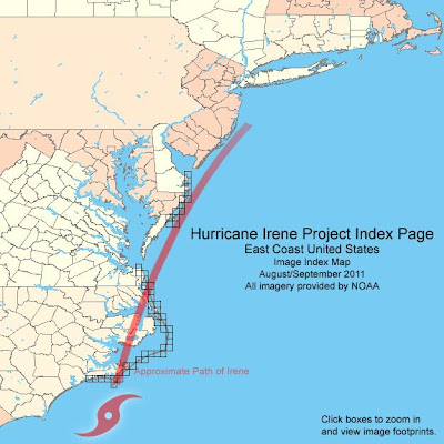
    美國艾琳颶風造成損壞 GoogleEarth 照片


    The damage from Hurricane Irene


    From: Google Earth Blog

    自 Google Earth 擷取對照圖   Damage before (Left) and after (Right)
    a section of Highway 12 being washed away on North Carolina's Outer Banks


     NOAA's Hurricane Irene Project Index Page