Dynamic View:
顯示具有 Google Maps 標籤的文章。 顯示所有文章

8/11/2012

菲律賓洪水災害地圖 / Philippines Flood Map

Resources related to the 2012 Philippines flood

On Monday, 6 August 2012 a Southwest Monsoon brought by Tropical Storm Haiku hit the Island of Luzon, Philippines and brought 24 hours of torrential rains that triggered disastrous flooding. NCR, Region I, III and IV-A are worst hit, with more than 800,000 persons affected. More than 250,000 people are in evacuation centers. Source: National Disaster Risk Reduction and Management Council.

Google Crisis Response

Philippine Flood hazard maps


Flood hazard maps


Reference: 

Monsoon rains swamp Philippine capital, markets shut | Reuters 


6/21/2012

菲律賓洪水災害預警地圖 / The Philippines Flood Hazard Map


Project Noah is a new Google Maps based flood hazard warning map from the Philippines' National Operational Assessment of Hazards and Risks (NOAH).

The map includes a number of weather layers. It is possible to view an animated radar layer from MTSAT. It is also possible to get the latest stream and rain gauge readings from across the country. If you want to know the current weather in the Philippines you can also select to view the Weather Outlook layer on the map.


Noah 計畫是一個建構在 Google Maps 的洪水災害預警地圖系統,包括很多圖層及目前天候。如下圖

Probability of Rain

Flood MAP

Pressure / Rainfall Contour

MTSAT
Weather Station

Rainfall

Temperature

Water Level

Doppler

Source: The Philippines Flood Hazard Map by Keir Clarke, Noah

6/02/2012

被災地の上空写真を一刻も早く人々の手に(1) – 東日本大震災と情報、インターネット、Google

東日本大震災と情報、インターネット、Google

被災地の上空写真を一刻も早く人々の手に(1)


震災直後、被災地に家族や知人のいる人々は、焦燥に駆られた。津波はどこまで及んだのか? 家は流されていないか? Google は、人工衛星からの写真を提供することで人々の不安を少しでも和らげようとした。
2012 年 6 月 1 日掲載

衛星写真に記録された仙台空港の復興


Google Earth を起動し、時計のマークをクリックすると時間を巻き戻せるスライダが現れる。


Google Earth で最新状況を伝える

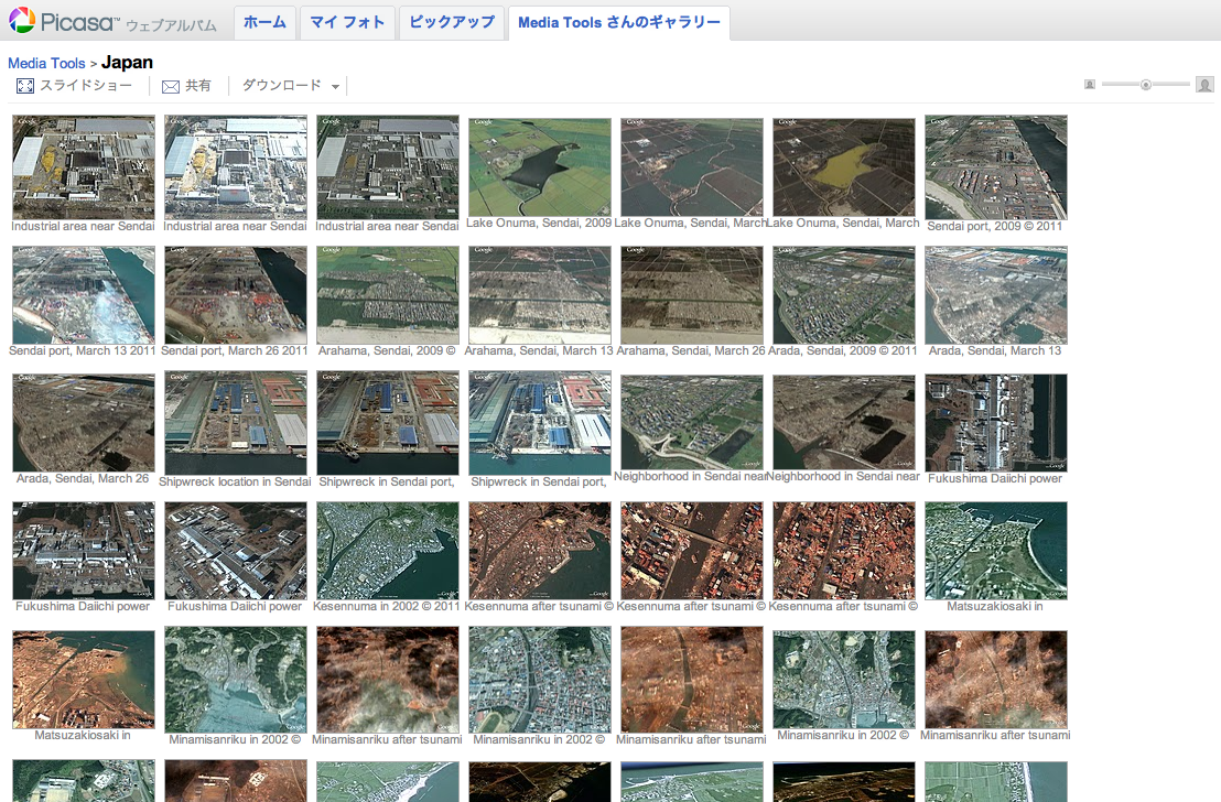
Picasa ウェブアルバム上で公開された衛星写真。


Google マップのマイマップから衛星写真を呼び出す

河合は Google マップのマイマップ機能を使って地図から該当する衛星写真を呼び出せるようにした。


Read More 続きを読む >> 被災地の上空写真を一刻も早く人々の手に(1) – 東日本大震災と情報、インターネット、Google


5/02/2012

空中街景(環景) / Aerial Street View (Panorama)


非Google官方街景 / Unofficial Google Street View
點擊影像觀看 / Click images to view

Panoramic Aerial Photography worldwide , Tours From Above

New York City Aerial virtual tour designed by John Colebrook - Pixelcase

Google Map • 360° Aerial Panorama, Airpano
Aerial Virtual Tours, VR Web Design
,Panoramic World, 360Cities

3/07/2012

調查者的足跡:史語所民族學田野照片與標本地理資訊系統

在1920-1940年代的中國,中央研究院歷史語言研究所的研究人員,進行了大規模的民族學調查計畫。在田野調查裡,研究走訪、採集各地民族的民族文物、文書與田野照片。這批彌足珍貴的民族學調查資料,對當代中國西南少數民族之民族學、歷史學和各種人文學科,均具有相當重要的研究參考價值。

史語所透過數位典藏計畫的整理與研究,將「民族文物」與「田野照片」的數位化資料結合Google Map,嘗試以地理資訊系統模擬早期民族學調查路線軌跡,並透過官方族稱、採集地點、主題類別的分類整理,關鍵字查詢,使中國西南少數民族資料庫能在圖像化的地理資訊提供檢索結果連結。

網址:調查者的足跡:史語所民族學田野照片與標本地理資訊系統
系統開發:中央研究院人社中心地理資訊科學研究專題中心

參考:史語所早期民族學調查地理資訊系統之實務應用(PDF) 


調查者的足跡:史語所民族學田野照片與標本地理資訊系統


2/24/2012

以 Google Maps 呈現惠妮休斯顿的一生 / Whitney Houston’s journey of Life on Google Maps

Mibazaar's latest map “Whitney Houston’s journey of Life” on Google Maps. The map animates thru events in Whitney Houston’s life, from birth, school, grammy awards, super bowl appearance, concert at Norfolk Virginia for troops returning from Persian Gulf, and then her untimely death at Beverley Hills, California.

You can disable the autoplay mode by clicking on the arrows at lower left corner of the map.

Mibazaar 將惠妮休斯顿一生旅程,自出生‧求學‧獲葛萊美獎‧各地演唱直至比佛利山辭世呈現在谷歌地圖上。
左下角可控制(自動)播放。

R.I.P. Whitney Houston

Whitney Houston’s journey of Life

via: Mibazaar Blog

1/03/2012

2012跨年煙火(短片)精彩回顧 / Wonderful New Year's Eve Fireworks 2012 : Review on Google Maps


New Year's Eve Fireworks 2012


12/23/2011

噪音污染地圖 / Sound Pollution on Google Maps

AirCasting 用於測量室外噪音,是一個用您的智慧型手機來記錄、繪製和分享環境數據的平台。目前可上傳手機的麥克風錄得的聲級數據。不久,將納入包括分貝計(聲級計)和污染傳感器等設備到AirCasting平台上。

AirCasting is a platform for recording, mapping, and sharing environmental data using your smartphone. Currently, AirCasters can upload sound level data recorded by their phone’s microphone. AirCasting is intended for measuring outdoor noise. Soon, we’ll expand the range of devices that plug into the AirCasting platform to include sound-level meters and pollution sensors. AirCasting lets you broadcast what’s happening in your environment, crowdsource your information with that from other AirCasters, and identify patterns and commonalities.

To start recording, mapping, and sharing sound level data for your neighborhood, simply download the AirCasting app to your Android device and press play. Don’t have an Android device? Check out the AirCasting maps to see if someone has already contributed data for your area.


Air Casting Map


Free App: Android 2.1 and up


12/20/2011

街景聖誕卡 / Merry X'mas from Street View

Merry Christmas & Happy New Year from Google Maps, Street View.
Share greeting cards with your friends!

Everyone Deserves a White Christmas

Shelter - House Bling Christmas Cards

Share a Carol with Street View
A Holiday Message


GeoGreeting
Xmap

12/15/2011

日出日落時間地圖 / Sunrise and Sunset Times on Google Maps

想知道某日、某地、日出、日落、月出、月沒等時間,讓 SunriseSunsetMap 告訴你。

  1. 先設定你的時區。
  2. 移到你要的位置(放大、縮小、平移)後, 於圖上點擊地點,選定日期,就會幫你算出時間。

如圖示為2012年第一道曙光台東蘭嶼、三仙台時間,可與中央氣象局比對數據。無法追曙光的朋友也可以算算你當日所在地日出時間,早起迎接新的一年。
另有APP(須付費用)。

With this map, you can find sunrise, sunset, moonrise and moonset times for 2011, 2012 and beyond for any location worldwide, simply by clicking the map. The right time zone for the location will be selected automatically if possible, or you can choose one yourself.

Set Time Zone / 設定時區


SUNDROID App

via: www.sunrisesunsetmap.com, 中央氣象局, 迎元旦曙光 本島三仙台起跑

12/13/2011

日本大地震(海嘯)前後街景比對 / Google Street View - Japan: Before and After the Earthquake and Tsunami

MEMORIES for the FUTURE
Japan: Before and After the Earthquake and Tsunami
Pre- and post-disaster imagery in Google Street View

未来へのキオク
いま、被災地をストリートビューで撮影しています。そして、過去の風景も大切に残します。


Before
After

Before
After


via: 未来へのキオク, MEMORIES for the FUTURE

11/12/2011

人口爆炸地圖 / Human Population Explosion on Google Maps (Earth)


你在世界人口扮演什麼樣的角色?於網站 互動資料:世界人口70億和你 輸入生日便得知。

Where do you fit into 7 billion? Enter your date of birth to find out: The world at seven billion

Download National Geographic's 7 Billion iPad app. FREE – Limited Time!


National Geographic : 7 Billion is a BIG Number


7 Billion People: How will we Sustain a More Populated Planet? 
Using Landsat data can help us track trends in key resources


via: NPR Radio, National Geographic, Thematic Mapping Engine, 7 Billion Actions, CBS News, USGS, 聯合報

11/07/2011

Google地圖-即時衛星影像(預測版) / Google Maps Real-Time Satellite View

Gidi Vigo 利用Flash做了一個有趣的預測版 Google 地圖-即時衛星影像(如果會上線的話),請點擊以下圖片來體驗一下。

Gidi Vigo has created a fun little Flash movie that previews what Google Maps live satellite view will look like. Click on the picture to view animation.


Moving Maps


Google Earth live?


via: Google Maps Real-Time Satellite View, Moving Maps, Google Earth live?

11/04/2011

臺灣觀光影片景點地圖 / Google Maps - Taiwan’s Scenic Spots Map

臺灣觀光影片景點地圖  The Tourism Bureau’s Film about Taiwan’s Scenic Spots: “Time for Taiwan – My Beautiful Island” 

交通部觀光局於今年夏天推出“Time for Taiwan—My Beautiful Island”(旅遊臺灣就是現在—我的美麗之島)首部電影宣傳短片,觀光局特別結合Google Map的地圖標記功能,把影片中曾出現的場景於地圖上作標示(網址為http://g.co/maps/gg8ys),讓喜歡臺灣的網友們能夠親自造訪影片中出現的美麗風景,以及街頭巷尾中展現臺灣生命力的人物,跟著影片旅行臺灣,用心感受臺灣的美好!
更多...


”Time for Taiwan – My Beautiful Island” is a popular film made by the Tourism Bureau to promote Taiwan’s scenic attractions. Since the film’s release, many fans have inquired about the locations where the film was shot. To help interested viewers find the scenic spots featured in the film, we have listed them below and have included their Google maps (URL http://g.co/maps/gg8ys).
Read more ...


via: Taiwan-The Heart of Asia, 中華民國交通部觀光局

10/26/2011

土耳其7.2級強震 / Powerful earthquake strikes Turkey

土耳其東南部與伊朗接壤的凡城省23日發生黎克特制7.2級強震,此次地震為土耳其12年來最強,震源深度僅10公里,屬淺層地震。土耳其位於歐亞板塊震帶,此地震帶近年地殼運動甚為活躍。地震發生於當地時間23日13時41分,震央位於塔班里村(Tabanli),靠近伊朗邊境。
美國地質調查局稱,地震震級為7.3級。當天晚些時候,土耳其方面將震級更正為7.2級。
除了與時間賽跑,營救受困人員外,當局目前最大的隱憂是,由於凡城位於土耳其第一大湖「凡湖」東岸,一旦大地震導致凡湖移位,大量湖水恐將灌入鄰近區域,使災情更加一發不可收拾。
土耳其位於歐亞板塊地震帶,是全球三大地震帶之一。地震主因是印度洋在印尼地區隱沒,印度半島向北與亞洲大陸發生碰撞,以及非洲大陸與歐亞大陸碰撞所造成。


The U.S. Geological Survey initially reported the quake had a magnitude of 7.3, then revised it down to 7.2.
Turkey is a tectonically active country that experiences frequent destructive earthquakes. On a broad scale, the seismtectonics of the region near the October 23, 2011 earthquake are controlled by the collision of the Arabian Plate and Eurasian plates; at the latitude of this event, the Arabian plate converges with Eurasia in a northerly direction at a rate of approximately 24 mm/yr. West of the October 23, 2011, earthquake tectonics are dominated by strike-slip faulting on the East (in southern Turkey) and North (in northern Turkey) Anatolian fault zones. These large, translational fault systems extend across much of central and western Turkey and accommodate the western motion of the Anatolian block as it is being squeezed by the converging Arabian and Eurasian plates.

Read also: Understanding the 7.2 magnitude earthquake in East Turkey (October 23, 2011)

Read also : New Insights into the October 2011 Van (Turkey) Earthquake – detailed analysis by the CEDIM Forensic Earthquake Analysis Group


Google Crisis Response : 2011 Turkey Eathquake, include Person Finder, Resources, Important Telephone Numbers, Maps and satellite imagery, News and Updates.

社群媒體地圖 / ESRI Social Media Map

Turkey Quake Map: Click to see animation

Click to see more Photos: Powerful earthquake strikes Turkey
7.2 Earthquake In Eastern Turkey 10-23-2011

CCTV shows moment when earthquake

Aerial of earthquake-hit Turkey shows full extent of damage

via: Earthquake-report, 星島日報